Documentation That Captures Every Structural Impact
Structural Damage Assessment & 3D Mapping in Oceanside for properties affected by fire, storm, or large-loss events
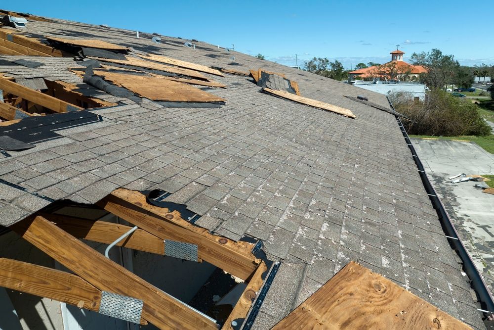
Lion Public Adjusting uses 3D mapping technology and drone imaging to document structural damage across properties in Oceanside and throughout Southern California. This approach captures precise measurements and visual evidence that standard inspections often miss, creating detailed records of compromised framing, roof systems, exterior walls, and foundation shifts. Property owners dealing with fire damage, storm impact, or extensive structural failures rely on this level of documentation to support claims that reflect the true scope of repair needs.
The assessment process involves deploying drone systems equipped with high-resolution imaging and laser-based measurement tools to map damaged areas from multiple angles, then compiling that data into three-dimensional models that show exactly where structural elements have shifted, collapsed, or weakened. This method records conditions that are difficult to communicate through photos alone, such as roof deflection patterns, wall displacement measurements, and the extent of char penetration in fire-affected framing. Insurers and contractors can review the same spatial data, reducing disputes over what needs replacement versus repair.
Request a full structural assessment to establish a complete visual and technical record of your property's current condition.
How Mapping Technology Improves Claim Communication
The 3D mapping system generates a layered digital model of your property that annotates each damaged component with measurements, material identification, and condition notes. Adjusters can navigate through the model to verify structural findings without requiring multiple site visits, and contractors receive precise dimensions for estimating replacement materials and labor. This reduces the back-and-forth that typically delays claims when insurers question the extent of hidden damage or request additional inspections.
After the assessment, you receive a compiled report that includes annotated imaging, measurement data, and a narrative explaining which structural elements require immediate attention and which pose long-term stability concerns. The visual clarity of drone-captured exterior damage combined with interior mapping eliminates ambiguity about whether load-bearing walls, roof trusses, or floor joists have been compromised. This documentation becomes the foundation for negotiations with your insurance carrier, particularly in large-loss scenarios where settlement amounts hinge on accurate representation of structural compromise.
The service does not include repair work itself but provides contractors with the technical data they need to develop accurate scopes of work and ensures that your claim submission reflects conditions as they exist, not as estimated from limited ground-level photos. Properties with complex roof lines, multi-story construction, or extensive fire-affected framing benefit most from this level of detail, as these conditions are difficult to fully assess without aerial and three-dimensional perspectives.
What Property Owners Ask About Structural Documentation
Clients preparing for large-loss claims or managing post-disaster recovery often want to understand how mapping technology integrates with the insurance process and what the assessment reveals.
What does 3D mapping capture that standard inspections do not?
The technology records spatial relationships between damaged components, showing how roof sag affects wall alignment or how fire penetration varies across different framing members, which helps identify systemic failures rather than isolated damage.
How long does a full structural assessment take?
For most residential properties, drone imaging and interior mapping are completed in one site visit, with the compiled 3D model and report delivered within several days depending on the complexity of the structure and the extent of damage.
Why is this documentation important for fire and storm claims?
Insurers often challenge the necessity of full structural replacements when damage is not uniformly visible, and detailed mapping provides measurable proof of compromised load-bearing elements, heat-affected framing integrity, and wind-driven displacement that justify comprehensive repair scopes.
Does Lion Public Adjusting coordinate with contractors during the assessment?
Yes, the firm shares technical data directly with your chosen contractors so that repair estimates align with documented conditions, reducing disputes over scope and ensuring that bids reflect actual structural needs rather than assumptions.
When should this service be requested?
The assessment should occur as soon as it is safe to access the property after a loss event and before insurers complete their initial inspection, ensuring that your claim file includes the most detailed documentation available from the outset.
Lion Public Adjusting provides structural assessment services designed to support claims where accurate documentation determines settlement outcomes. Schedule your assessment to establish a complete technical record before negotiations begin.